River Erosion in Bangladesh: Satellite Evidence and Human Cost
Cross-domain erosion, displacement, and bank protection analysis
BDPolicy Lab · Last updated 2026-05-08
Executive Summary
Bangladesh's river system, the confluence of the Ganges-Brahmaputra-Meghna (GBM) delta carrying approximately 1.0 billion tonnes of sediment annually, erodes an estimated 5,500 hectares of riverbank per year across 20 erosion-prone districts. This erosion rate, yielding a severity score of 100.0/100, is critical and demands immediate policy intervention. The human cost is staggering: an estimated 176,000 people displaced annually, 5.0 million char dwellers living in chronic vulnerability, and over 1,100,000 families cumulatively affected. With agriculture contributing 11.2% of GDP in a country of 174 million people, river erosion is not merely a geomorphological phenomenon but a structural driver of poverty, displacement, and urban migration that undermines Bangladesh's development trajectory.
National Erosion Profile
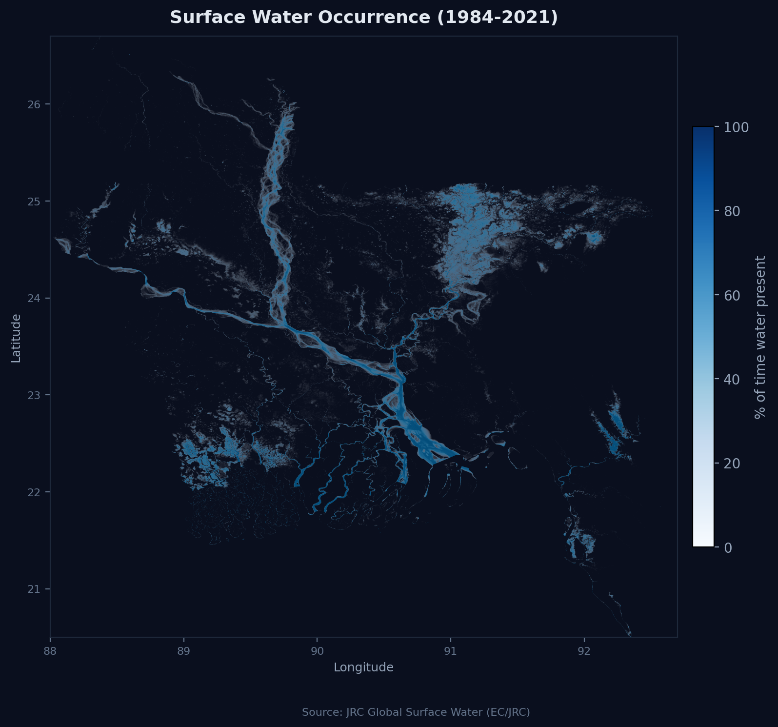
The monitored river network collectively erodes 5,500 hectares annually, with year-on-year change of +0 hectares (+0.0%). The Jamuna (Brahmaputra), at 1,600 ha/year (29.1% of total), contributes significantly to total bank loss. The Padma contributes 900 ha/year and the Meghna 350 ha/year, with the remaining 2,650 ha/year distributed across smaller rivers including the Teesta, Dharla, Gorai, and Karnaphuli.
Bangladesh sits at the terminal end of the world's largest river delta system. The GBM watershed drains approximately 1.72 million km2 of the Himalayan range and Indo-Gangetic plain, delivering the world's highest sediment load. Erosion and accretion are natural delta processes, but the balance has been fundamentally altered by human intervention. Upstream dams and barrages, particularly India's Farakka Barrage on the Ganges and the Gazaldoba Barrage on the Teesta, have modified sediment transport and flow regimes. The Teesta's dry-season flow has declined to roughly 25% of its pre-barrage volume, concentrating erosive energy in the remaining channel. Sand mining removes the coarse sediment that naturally armours banks. Flood control embankments concentrate hydraulic energy against unprotected reaches.
By regional comparison, Bangladesh's erosion rates are among the highest globally. India's Brahmaputra reach in Assam experiences comparable bank migration rates (100-500 m/year in active reaches), but Bangladesh faces a compounding factor: population density of 1,265 people per km2 means every hectare eroded displaces more people than equivalent erosion anywhere else on earth. Nepal's Koshi River, which shifted its course by over 100 km in 2008, illustrates the catastrophic potential of GBM system channel migration, a risk Bangladesh faces at continental scale.
River-Level Analysis
The Jamuna is one of the world's most actively braided rivers, with a braiding index of 3-5 and channel widths reaching 12 km during monsoon peak flow. Channel migration rates of up to 1 km per year have been documented, with the river consuming entire villages within a single monsoon season. The Jamuna's braided morphology means erosion is not confined to outer meander bends (as in classical river mechanics) but occurs unpredictably across the full channel width as braids shift, merge, and split. This morphological complexity makes erosion prediction extraordinarily difficult and renders conventional bank protection approaches (designed for single-channel rivers) largely ineffective.
The Padma, formed by the Ganges-Jamuna confluence, exhibits extreme meander migration. The Padma Bridge (Padma Setu), opened in June 2022, required a 6.15 km span precisely because the river's channel instability made shorter, bank-anchored approaches unviable. The engineering challenge of the Padma Bridge, one of the most difficult river crossings ever attempted, illustrates the scale of the forces at work. The Padma's meander migration has historically consumed towns, bazaars, and critical infrastructure, most notably the repeated destruction and relocation of Shariatpur district's administrative center.
The Meghna, carrying the combined discharge of the Surma-Kushiyara system, generates 350 ha/year of erosion, concentrated in its lower reaches where tidal influence interacts with fluvial discharge. The mid-sized rivers, particularly the Teesta, face erosion patterns driven by upstream flow regulation rather than intrinsic channel dynamics. The Teesta, whose dry-season flow has been drastically reduced by India's Gazaldoba Barrage, now oscillates between extreme low flows (causing channel contraction and bank desiccation) and monsoon surges (causing sudden, violent erosion of desiccated banks). This "barrage-altered erosion" pattern is distinct from natural braided river dynamics and is directly attributable to transboundary water management failures.
The Human Cost
River erosion displaces an estimated 176,000 people annually, exceeding 100,000 people annually, a humanitarian crisis that receives far less international attention than cyclone or flood displacement. The Bangladesh Water Development Board (BWDB) and the Centre for Environmental and Geographic Information Services (CEGIS) have documented cumulative displacement affecting over 1,100,000 families, a number that grows with each monsoon season.
The displacement cascade follows a predictable and devastating trajectory. Erosion-affected households first retreat to the nearest embankment slope or surviving char land, where they live in extreme precarity without access to sanitation, clean water, or stable shelter. Many then migrate to Dhaka, Chittagong, or other urban centers, joining the informal labor force in garment factories, construction, and rickshaw pulling. Research by the Refugee and Migratory Movements Research Unit (RMMRU) at Dhaka University has documented that a significant proportion of garment workers in Dhaka's industrial zones are erosion-displaced migrants from Jamuna and Padma chars, making river erosion a direct upstream driver of the labor force that produces Bangladesh's largest export.
The erosion-poverty nexus operates through permanent asset destruction. Unlike flood damage, which is temporary and partially addressable through relief, erosion permanently removes the land asset itself. A smallholder farmer losing a 0.5-hectare plot loses not one season's crop but the family's primary productive asset, savings vehicle, and social collateral. Land ownership determines access to agricultural credit, input subsidies, and community standing. The estimated agricultural output loss of $11.0 million annually understates the true economic cost, which includes destroyed infrastructure, disrupted livelihoods, migration costs, and intergenerational poverty transmission.
Approximately 5.0 million char dwellers live on river islands that are themselves products of past erosion and accretion cycles. Char livelihoods are precarious: soils are immature and sandy, infrastructure is absent, flood risk is extreme, and land tenure is contested. The Char Development and Settlement Project (CDSP), funded by the Netherlands and implemented through BWDB, has demonstrated that systematic char development, including land surveying, tenure allocation, raised homesteads, and agricultural extension, can significantly improve char livelihood outcomes. But CDSP covers only a fraction of active char areas.
Bank Protection and Institutional Response
BWDB has constructed approximately 340 km of bank protection works along major rivers, primarily using hard engineering approaches: concrete-block revetment, geobag revetment, and groynes designed to deflect flow away from vulnerable banks. These works, while effective where properly maintained, face several structural limitations.
First, hard engineering is extraordinarily expensive. Bank revetment costs $5,000-$15,000 per running meter depending on river width and hydraulic conditions, placing comprehensive protection of all vulnerable reaches beyond fiscal capacity. BWDB's 340 km of existing works represent a fraction of the total erosion-prone bank length. Second, hard structures require continuous maintenance: monsoon hydraulic forces regularly undermine foundations, dislodge geobags, and breach revetments, requiring annual repair that strains BWDB's limited operational budget. Third, hard engineering can transfer erosion pressure downstream or to the opposite bank, creating new vulnerability rather than eliminating it.
Soft engineering approaches, including bioengineering (vetiver grass, willow planting), mangrove establishment in tidal reaches, and strategic sandbar management, offer lower-cost alternatives that work with natural processes rather than against them. Bangladesh's experience with mangrove-based coastal protection (notably in the Sundarbans buffer zone) demonstrates the viability of ecosystem-based approaches, but their application to active river erosion remains limited and under-researched.
CEGIS operates a satellite-based erosion monitoring program covering 20 districts, using Landsat and Sentinel-2 imagery to track bank line changes and predict erosion risk zones. This technical capacity is world-class, but the translation of monitoring data into actionable early warning for at-risk communities remains inadequate. The dredging capacity of 25 MCM/year, managed by BIWTA and BWDB, serves primarily navigational purposes rather than erosion management.
Policy Recommendations
Four interventions, grounded in the satellite evidence and institutional assessment, offer the highest return:
- National River Erosion Early Warning System: Link CEGIS satellite monitoring to a public warning system providing at-risk households 6-12 months notice of probable erosion. Pair with a compensation mechanism (land-for-land swap on stabilized chars, or cash transfer equivalent to 3 years' agricultural income) that prevents the asset-destruction-to-destitution cascade. The Bangladesh Climate Change Trust Fund provides a financing vehicle, and mobile phone penetration (>95%) enables direct warning delivery.
- Char Land Reform and Settlement Authority: Consolidate the fragmented governance of char lands under a single authority mandated to survey, allocate, and service newly formed chars for settlement by erosion-displaced families. The CDSP model demonstrates feasibility; the constraint is scaling from project-level to national-level coverage. Legal reform to simplify khas land allocation and protect new settlers from eviction by local power brokers is prerequisite.
- Ecosystem-Based Bank Protection Program: Complement BWDB's hard engineering with a systematic program of bioengineering and nature-based solutions on lower-energy reaches. Vetiver grass hedgerows, riparian buffer strips, and strategic sandbar stabilization can reduce erosion at a fraction of revetment cost. Enforce a ban on sand mining within 5 km of settlements and critical infrastructure, using Sentinel-2 satellite monitoring to identify active mining sites.
- Teesta and Transboundary Water Cooperation: Pursue the stalled Teesta water-sharing treaty with India, framing the negotiation not only in terms of dry-season flow allocation but also in terms of sediment management and erosion impact. The Teesta's barrage-altered erosion pattern is a direct consequence of upstream regulation; bilateral cooperation should include joint sediment monitoring, coordinated barrage operation during monsoon onset, and shared investment in downstream bank protection.
Data sources: BWDB Annual Report, Centre for Environmental and Geographic Information Services (CEGIS), SPARRSO, Char Development and Settlement Project (CDSP), World Bank WDI, Landsat/Sentinel-2 satellite imagery.
Sources
BWDB, CEGIS, SPARRSO, World Bank WDI
Generated on 2026-05-08.